Improved hydro-met services help prepare for extreme weather in Mozambique
Mozambique, on Africa’s southeast coast, is one of the most vulnerable countries in the world to climate change and is often affected by extreme weather conditions. The HydroMet project has managed to improve the country’s water and weather systems. Now meteorologists and national disaster management authorities have a modern forecast-based early warning system to help protect people and assets.
“We have 2,700 kilometres of coastline and are located downstream of 9 major rivers,” Anacleto Duvane, the National Project Director for Instituto Nacional de Meteorologia (INAM) explains. “Many people live in low-lying areas, and much of the city of Beira is under sea level. Storm surges from tropical cyclones cause flooding. When there are heavy rains in the interior, like in Malawi, Zambia, Zimbabwe or South Africa, rivers downstream in Mozambique can flood, too.”
Climate change is causing more extreme weather events, such as Cyclone Idai, one of the worst tropical cyclones ever recorded in the southern hemisphere. In 2019, the cyclone made landfall near Beira in Mozambique with a 4.4-metre storm surge, leaving billions of euros in damage and 1,593 people dead.
Having accurate hydrological and meteorological information is critical as extreme weather events become more common. NDF provided 4.4 million euros in funding to build a system which provides reliable and timely information that increases climate resilience and lowers risks to local communities in Mozambique. The project ran from 2012 to 2022 and strengthened information management, weather forecasting and information delivery.
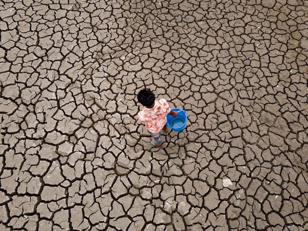
Climate change causes extreme weather events, such as drought. Photo: WMO/Amdad Hossain
Better data collection
“We wanted to improve the system with a better early warning system to reduce the impact of disasters,” Duvane continues. “We needed to build our capacity to gather data, analyse it and make forecasts.”
Mozambique has weather observations going back over a century, with some gaps. The project helped recover this historic data and input it into INAM’s computers for long-term analysis.
They also gather and analyse more recent data from satellites and weather stations. Some old stations were rehabilitated while new stations were installed which met global World Meteorological Organization (WMO) standards. For example, old mercury thermometers and barometers were replaced with modern digital ones.
“We see a positive result already today in weather monitoring. The results will be increasingly better in the next thirty years when we can reconstruct more consistent climatological series, which will allow us to carry out climate studies as well as calibrate weather and climate forecast models,” says Duvane.
Forecasts to the public and authorities
Data is no good unless it is used properly, so the project also helped to provide software and equipment for data management and modelling using WMO standards. Additionally, INAM staff received training and development to boost institution and staff capacity. Even INAM’s headquarters in Maputo was refurbished with modern equipment. All this work is to support the most important part of the project: getting better weather and climate information to the public.
“We have many different stakeholders. Regular weather forecasts go to TV and radio stations, or people can look at our website,” Duvane explains. “If an extreme event is coming, the information goes to disaster management authorities at provincial and district levels and municipalities. They tell their local citizens what to do in case of an emergency. For instance, if a dangerous heat wave is coming the health services are informed so they can warn people and prepare for possible patients.”
The new storm and wave monitoring system, FEWS-INAM, provides information to fishing communities, port operators, shipping companies and safety agencies along the coast. They receive regular daily bulletins with forecasts about waves, water surges, wind speed, rainfall, temperature and air pressure. Subscribers can customise the information they receive based on their needs. This information helps with daily operations, such as for ports and fishers, as well as provide early warnings in case of emergency.
Strong collaboration yields positive results
Normal weather forecasting is just for a few days in advance, but meteorologists can also do more long-range seasonal forecasting, such as planning for the October-March wet season.
“We share information with a national climate outlook forum,” says Duvane. “Road transport authorities get better information to prepare roads for rains, or to get ready for possible flood repairs. Water management authorities get rain predictions which they use to check dams and flood basins. The health sector uses the information to model the possible occurrence of water-borne diseases.”
The project was part of the World Bank’s broader National Water Resources Development Project. The World Bank was a partner and co-financer in the project. Expert organisations like the UK Met Office, Deltares and the Norwegian Meteorological Institute also supplied their services.
“We had good collaboration with our partners, including NDF,” Duvane says. “Right now, we are gaining experience and learning how to improve. This project has really helped us to help our end users and the people of Mozambique. Due to the good implementation of the project, Mozambique was selected to be part of the first batch of countries benefiting from the Systematic Observations Financing Facility (SOFF) initiative, also supported by NDF.”
Having accurate meteorological information is vital to prevent damage in communities. Photo: WMO/Iyanuoluwa Omogbadegun